intro:
Western mindsets on the northern hemisphere

Mercator Misconceptions: Clever Map Shows the True Size of Countries
Nopv 2018https://www.visualcapitalist.com/mercator-map-true-size-of-countries/
In 1569, the great cartographer, Gerardus Mercator, created a revolutionary new map based on a cylindrical projection. BUT, and it it is a big but, Mercator’s map inadvertently also pumps up the sizes of Europe and North America. Visually speaking, Albeit no-one complained at the time.... At least in our euro-centered view of the world.
PART 1___
A matter of perspective:
- A perspective from .......: does it matter? to whom?
- Get used to these new options ... here
- Pacific-centred?
- Azimuthal polar projection?

What is the Center?
- Sinocentrism in China
- From 211 BCE to 1831 CE
When China was the Center of the world and we were Barbarians
"The Complete Map of the Myriad Countries" (Wanguo Quantu), Jesuit's adaptation of Western geographic knowledge to Chinese cartographic standards (early 17th century).
PART 3
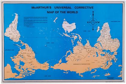
McArthur's map -1979
PART 4
Ifrika - Africa
But no-one can fool everybody everytime!
 My fav goofs
Ifrika - Africa
But no-one can fool everybody everytime!
Columbus gets a lot of flak for mistaken the Americas for India, but c'mon, the guy couldn't exactly consult GPS and Google.

- George W. Bush:
- "Africa is a nation that suffers from incredible disease.”
- Paris Hilton
- “I love Africa in general. South Africa and West Africa. They are both great countries.”
- Britney Spears
- "I've never really wanted to go to Japan. Simply because I don't like eating fish. And I know that's very popular out there in Africa."
BONUS CATALAN MAP
MEDITERRANIAN: The best Catalan map 1375
-made in Mallorca by Abraham Cresques
«Cresques lo juhueu qui lo dit mapamundi a fet»
"Les cartes portolanes: la representació medieval d'una mar solcada", a body of knowledge regarding the map-makers of Majorca of the late middle ages that had not obtained the recognition it deserves in the English-speaking cartographical research world.
Crescques was the first to draw an ornate compass rose on a map. By the end of the 15th century, Portuguese cartographers began drawing multiple ornate compass roses throughout the chart.
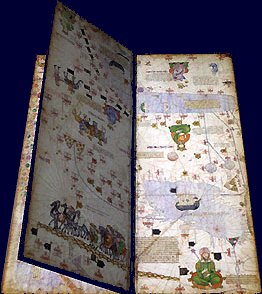
His son, Jafuda (Jehuda) , dues to the Crown persecutions of 1391 converted to Christianity, at which time he took the name Jaume Riba, Jacobus Ribus,Despite the map's rather approximate cartographical design, which emphasize the earth's spherical shape and the state of the known world, many Indian and Chinese cities can be identified. The explanatory texts report customs described by Marco Polo and catalogue local economic resources, real ones or supposed ones. This, indeed, is perhaps the most interesting aspect of the Catalan Atlas : to the east of the well-defined Mediterranean world lie immense regions whose economic importance is clearly understood, but which remain mysterious and unexplored. This world of spices, silks, and fabulous riches described by Marco Polo is the one that Christopher Columbus would attempt to reach by a western route 117 years later.
Everybody makes mistakes sometimes....
Yanko Tsetkov -map of prejudice:
AND
Martin's Positive stereotypes: such as ‘Japanese and Koreans are all very smart’, ‘the French are very romantic’, and ‘all Canadians are polite.’”
Click an pick up your negative ones
mapping stereotypes
or Independence day!
No comments:
Post a Comment